THE RESEARCH CYBERINFRASTRUCTURE CORE (RCC)
A major accomplishment of the Hawaii EPSCoR Track 2 investment (FY 2009 – 2012) has been the development of the Research Cyberinfrastructure Core (RCC) (Fig. 1) currently operated and maintained by UH-CCRT and the Pacific Biosciences Research Center (PBRC) on the UH Manoa (UHM) campus. To demonstrate a capability of PACMAN to track / study the impacts of climate change scenarios on freshwater resources for local communities from “Arctic to Pacific”, it became obvious early on that a powerful environmental cyberinfrastructure platform was needed which did not exist at UHM. To address this need the RCC was designed to leverage upon previous UH-EPSCoR RII investment which established a base cyberinfrastructure platform that integrated environmental monitoring capability with distributed servers for data acquisition and management, fusion and integration, analyses and visualization. Hardware and software investments in EPSCoR Track 2 extended RCC’s capability as a core technological infrastructure able to robustly support the research / management objectives of UH researchers system-wide as an advanced, integrative, data management, storage and processing platform.

Figure 1. Conceptual components, applications and workflows in the RCC at UHM.
A. Hardware Upgrades
This was accomplished through hardware updates on the RCC to include installation of: 1) a Linux Web Server (Dell R210 II PowerEdge / Firewall; 8 GB memory, 450 GB storage) for robust processing of Drupal portal applications; 2) a high-capacity Application Server running Windows 2008 R2 (64 bit) SP1 (48 GB Quad Core / 3 TB RAID disk space) able to handle high-end geoprocessing and advanced visualization tasks; 3) to house the Data Library a modular 24 TB Dell MD-1000 PowerVault (Windows 2008 R2 - 64 bit / SP1) and; 4) for security a Data Backup Archive (Dell 510 PowerEdge, 16 GB Memory, 24 TB Disk Space RAID (18T) in 2 partitions). As a component in the Data Management Plan (explained below) to maintain robust and reliable performance of the RCC, service protocols were established for UH staff to monitor and maintain system integrity 24 hours / day.
B. Software Upgrades
The RCC functions as a distributed array of expandable, interconnected servers that combine a number of functions into a completely integrated platform. User access is provided through multiple secured avenues enabled on the RCC including: 1) open-source web-based Drupal Portals; 2) Virtual Private Networks (VPNs) with direct access to the databases; 3) ArcMap services and; 4) Remote Desktop Login accounts. Front-end Web Servers on the RCC control Web traffic and secured user authentication. Utilizing a Windows Server 2008 R2 SP1 platform, Microsoft SQL Server 2008 R2 and ArcGIS Server installed on RCC machines provide users with greater flexibility for creating customizable workflows to interact with data repositories for remotely analyzing, graphing and visualizing research data. Geospatial data are stored within a Spatial Database Engine (ArcSDE) for SQL Server where data can be uploaded or imported through ArcMap, ArcCatalog, or many other routes including MS Access VPN links and various web map Application Programming Interfaces (API’s). ArcMap is used to visualize data and create REST services through ArcGIS Server which may subsequently be used to create map-based API’s for applications in portal environments or stand-alone interactive maps accessible over the Internet. Examples of exploratory and interactive maps deployed with Adobe Flex, ASP.net and on ArcGIS.com are provided in subsequent sections of the Annual Report.
Built upon the RCC’s hardware / software platform, applications were developed through use-case examples (described below) with the overarching theme of improving the cyberinfrastructure capability at UHM and in the ‘doing’ improve UH’s research capacity as well as local community capacity to mitigate / adapt to climate change impacts on natural resources (particularly water) in the Hawaii Islands .
C. RCC Capabilities for Environmental Research, Management and Education
1. Open Source Drupal Portals
Portals provide the primary user collaboration / information content management environments in the RCC and provide a secure ‘doorway’ for users into RCC workflows . Open-source Drupal software was chosen for the portal platform because of its large community of user-developers, constantly improving “module” library, built-in server-based security options and adaptability to Linux and Windows platforms. The Development Team has focused on software / hardware challenges associated with creating robust workflows that allow reliable transfer of information between Drupal Portals and secured locations in the RCC’s Data Repository where information can be readily accessed by computation and / or visualization software applications and APIs (e.g. for statistical analyses, simulation / modeling, 3D exploration, etc.). Software upgrades from Drupal versions 5.x to 6.x to 7.x added additional complexity to the process as each version functions differently in the server architecture and care must be taken to protect the data stores yet maintain functionality. These significant technical challenges are continually being refined in the RCC and this effort will continue as ongoing R&D so as to improve / extend its operational capacity. Seven Portals are currently established / maintained for PACMAN projects and information entered by user groups continually contribute data to a growing, content-diverse RCC Data Repository.

Partly cyberinfrastructure innovation and partly community capacity building, The Kohala Center (TKC) Portal (Fig. 2) was envisioned as a community-based information resource. This RCC application example serves as a permanent repository for community-based social-ecological information of the Kona region of Hawaii Island. In addition to calendars and forums that allow Kona residents to stay connected / informed, the TKC Portal includes online forms for Citizen Science water quality data collection input, tools for uploading information (e.g. videos, documents, photos, etc.) such as historical / cultural maps, oral history videos, water quality data, community workshop documents, etc. Embedded in the TKC Portal for community use are state-of-the art map-based tools: 1)InteleView Java for 3D exploration; 2) Spatial Decision Support System (SDSS) (Fig. 3); 3) ArcGIS.com access to online / user-friendly GIS applications and; 4) CyberGIS research applications (e.g. Kahalu’u Bay Coral Reef Flex Map described below).
2. Spatial Decision Support
It became apparent early on in attempts to improve local community capacity to manage water resources in West Hawaii that very little infrastructure existed in the way of Internet-based planning tools suitable for resource management able to tap into available information resources pertaining to water. Therefore, in collaboration with The Redlands Institute considerable investment was directed at building into the RCC an ArcGIS Server-based Spatial Decision Support System (SDSS) (Fig. 3). A prototype SDSS was developed on Redlands Institute servers which provided secured user access through Portal environments to workflows which govern web-based water system interactions, data repository and characterizations through a geospatial decision process framework (Fig. 4). An integrated set of three primary tools were
Figure 3. Kona sewer infrastructure, tax key maps, watershed boundaries in the RCC’s SDSS.
constructed in the SDSS: (1) tools for geosimulation of the effects of climate change scenarios; (2) tools for assessment of watershed ecosystem health; and (3) tools for assessment and geovisualization of the impacts of community landscape changes. This sequence of tools was intended to consolidate the outputs of the scientific models in a geospatial, web-based environment so that community decision makers may have better understanding (a) of the potential effects of climate changes, and (b) of the potential effects of their land use decisions on their hydrologic and aquatic ecosystem resources. In the current year, the SDSS has been further tested / refined and migrated to the RCC at UHM to include its code architecture which initiates / retrieves data queries and graphing from remote repositories (e.g. EPA STORET and InteleSense Technologies). The SDSS is currently entirely operational on RCC servers housed on the UH Manoa campus.
3. “CyberGIS” – Coupling Cyberinfrastructure and GIS RCC  capability was extended in the current year into the realm of “CyberGIS” with the addition of ArcGIS Server software that interfaces directly with the Data Repository and SDE Database thus allowing a seamless integration of ArcGIS 10 with a spatiotemporal database, spatial analysis / visualization, spatial decision support and simulation / modeling. The powerful, open-source Adobe Flex visualization framework was adopted because of its generic codebase and compatibility with all major server back ends (e.g. Java, .NET, PHP, etc.) as well as its use of industry standards (e.g. REST, SOAP, AMF, etc.). Services through ArcGIS Server are created that interact ‘on the fly’ with data in the SDE Database which are visualized in the Flex framework (Fig. 5).
Figure 4. Data workflow from sensor networks through modeling results to SDSS Platform.
Figure 5. Operational example of CyberGIS application in the RCC’s Flex visualization framework.
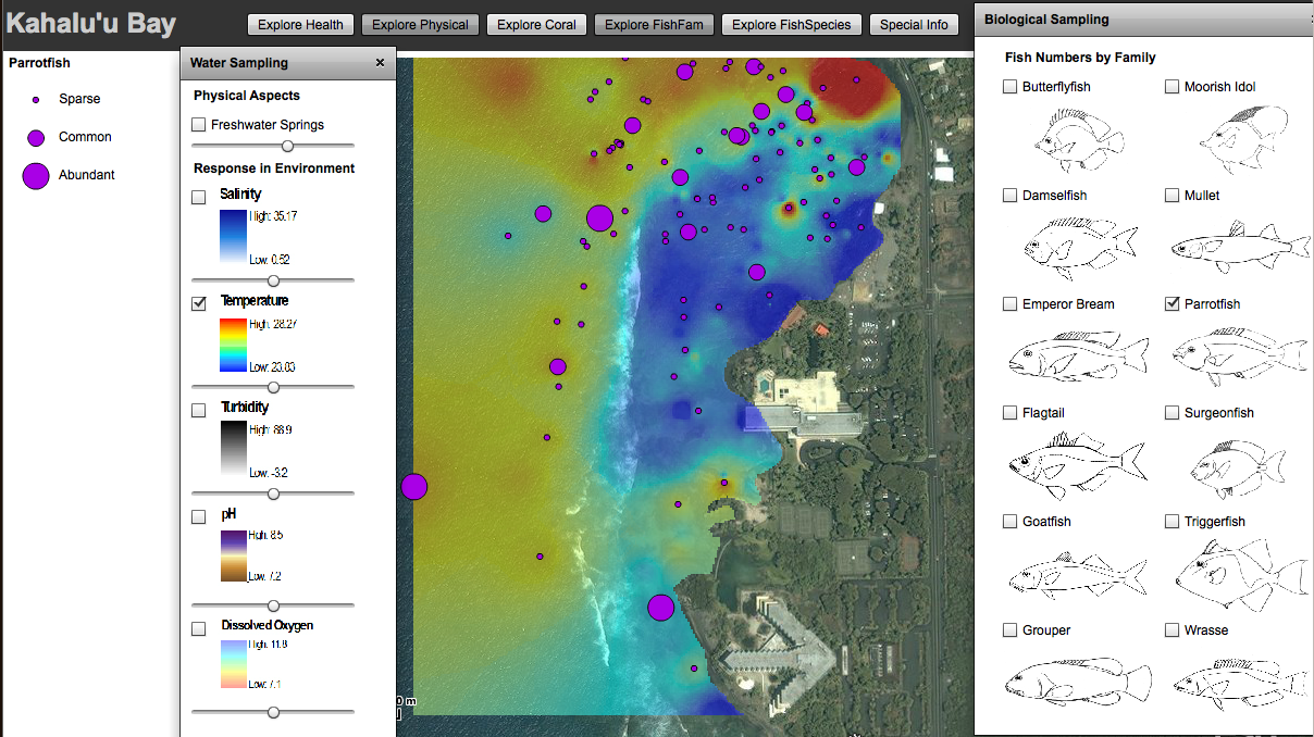
The ‘use case’ example for initial operational development of a CyberGIS application was a coral reef study in Kahalu’u Bay (Kona mountain-to-sea study region) conducted by doctoral candidate Kaipo Perez at the Hawaii Institute of Marine Biology (UHM) (Report in Appendix-A). The study provided a typical researcher ‘use case’ with a multidisciplinary dataset (i.e. numerical data including coral / fish distribution-densities, near shore water quality point data, Hawaiian traditional ecological knowledge, etc.). In addition to providing a focal point for CyberGIS development, this was crucial environmental information needed by the Kahalu’u Community Advisory Board to better manage coastal resources in the face of escalating tourism related impacts in Kahalu’u Bay.
As an operational example of the RCC’s CyberGIS capability (Fig. 5), environmental research data (reef / fish resources, temperature measurements) were uploaded into the SDE Database through a web-based form embedded in The Kohala Center Portal. ArcGIS Services were used to extrapolate temperature point data collected along the shoreline into a colorized grid clearly showing the relative locations of colder freshwater plumes entering the ocean. Abundance and distribution data for fish (and coral) species surveyed in Kahalu’u Bay were ‘binned’ from the SDE Database into abundance categories (i.e. sparse, common, abundant) and interactively displayed as associated colored circles to indicate their relative abundance / distribution on the reef. This ‘use case’ is typical of environmental research projects in which field data (e.g. species surveys of abundance / distribution, point data collections such as from sensors) are collected and researchers require tools for secure data input / storage, trend – pattern analysis and data visualization. Therefore, the RCC capacity developed in this ‘use case’ may be broadly extended to accommodate similar research projects at The University of Hawaii system-wide.